Geological sites in Bedfordshire
Recognising that there is much more to our geological heritage than is captured in the nationally recognised Sites of Special Scientific Interest (SSSI), we have identified additional sites that are of local significance. These are called Local Geological Sites (LGS) (once called RIGS) and they are selected primarily for their scientific and educational importance. They may also have considerable aesthetic value, as is the case with the chalk downlands. By bringing them to the attention of the public we aim to promote an awareness and interest in Bedfordshire’s geological heritage.
We identify, evaluate and designate sites across the county, particularly in areas that are accessible to the public. Whilst Local Geological Sites do not enjoy the same level of statutory protection afforded to SSSIs, they are recognised by Local Authorities, the Forestry Commission and by Natural England (the statutory nature conservation body of England). The network of sites is also used to inform planning policy, with the intention that they will be protected for the benefit of future generations.
Current sites include working and disused quarries, ancient stone monuments and major landforms such as chalk downland and lowland river valleys. Click on the site number on the map, or the site name in the keys, to find out about the important sites in Bedfordshire. You will find an explanation and key to the bedrock map in the Geology section of this website.

Local geological sites
Click on a number on the map to see the name of the site. The numbers link to the site information displayed further down the page, below the map. You can zoom in if you're using a touchscreen device
Accessible sites
|
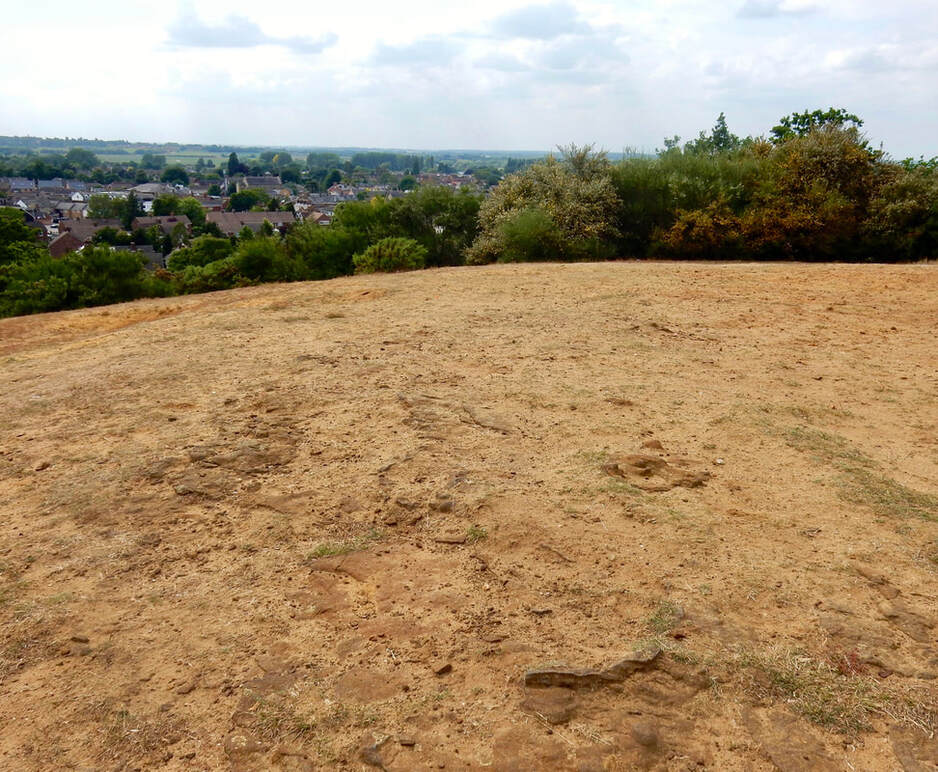
1. BARTON HILLS
A beautiful landscape in the Lower and Middle Chalk with a dramatic coombe in the steep face of the escarpment and a natural spring which forms a small stream, tributary dry valleys and soil creep terraces, as well as some small natural exposures of the Chalk. Take a look at the church which is built of flint and Totternhoe Stone, both from the local Chalk. National grid reference: TL 090 298 Click here to see the full Bedfordshire Local Geological Site Designation Form |

|
|
|
|
|
|
|
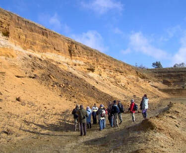
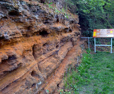
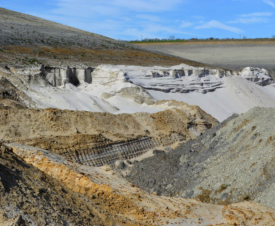
5. KENSWORTH NATURE RESERVE
This exposure of Chalk was created during the restoration of the enormous Kensworth Chalk Pit. There are many features of the Lewes Nodular Chalk here: white Chalk, small faults and solution hollows, beautiful flint nodules and the possibility of finding fossils, plus an information board. The area around the Chalk face has been designated a Nature Reserve on account of re-created calcareous grassland. National grid reference: TL 011 199 Click here to see the full Bedfordshire Local Geological Site Designation Form |
|
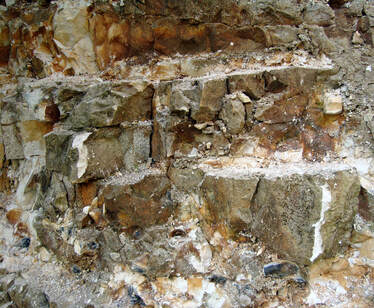
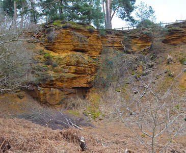
6. LANDPARK QUARRY
A crescent-shaped cliff, with deep scree at the foot, in a former quarry in the White Chalk, containing splendid flint nodules and fossils. It is within Landpark Wood, a Wildlife Trust Nature Reserve and access and the ability to manage it are difficult. National grid reference: TL 016 185 Click here to see the full Bedfordshire Local Geological Site Designation Form |

|
7. MUNDAY'S HILL QUARRY
This is a large working quarry in which the working has revealed a complete succession of Lower Cretaceous beds through the Woburn Sands into the Gault Clay. Access is accompanied and only by arrangement with the quarry manager. National grid reference: SP 938 280 Click here to see the full Bedfordshire Local Geological Site Designation Form |
|
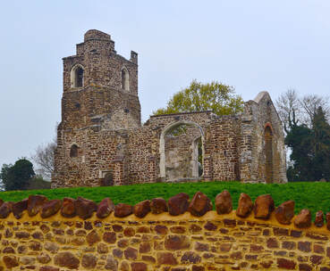
8. OLD ST MARY’S CHURCH, CLOPHILL
This ruined church used local Woburn Sands (once called Lower Greensand) building stone. It shows many of the features of this rust-red Cretaceous sandstone. On the Greensand Ridge Walk with views over the surrounding landscape from the church tower. The reconstructed wall includes a Wall of Geology, a section across the rocks of the county with an interpretation board. Clophill Ecolodges sit next door. The site is managed by the Clophill Heritage Trust. National grid reference: TL 092 389 Click here to see the full Bedfordshire Local Geological Site Designation Form |

|
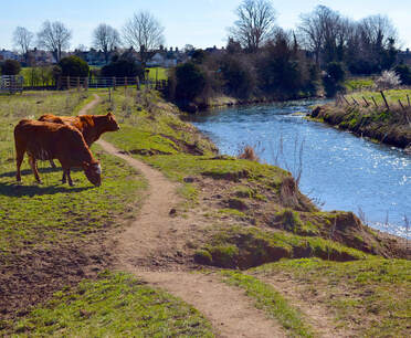
9. OUZEL VALLEY
This is a section of the River Ouzel valley where the meandering river has cut down through ice age deposits to create a series of river terraces. You may get glimpses of the underlying Woburn Sands where badgers have been digging. The site is crossed by public footpaths and is close to the start of the 40-mile Greensand Ridge Walk. National grid reference: SP 915 264 Click here to see the full Bedfordshire Local Geological Site Designation Form |
|
10. RIVER IVEL, BIGGLESWADE
This is a walk along the River Ivel on the Kingfisher Way next to Biggleswade Common. You can see modern river processes on this gentle meandering river and observe the slightly higher gravel terrace of Biggleswade Common, deposited by torrential seasonal rivers during the late Ice Age. National grid reference: TL 186 463 Click here to see the full Bedfordshire Local Geological Site Designation Form |
|
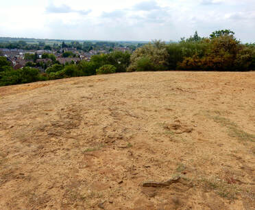
11. SANDY. THE PINNACLE RECREATION GROUND
This hilltop site forms a wonderful viewpoint across the broad valley to the west, where the River Ivel has cut through the Woburn Sands of the Greensand Ridge into the underlying soft Oxford Clay, with spreads of glacial and river deposits on top. The Pinnacle’s steep slopes are due to the resistant Woburn Sands which can be seen where the grass is broken through. National grid reference: TL 178 492 Click here to see the full Bedfordshire Local Geological Site Designation Form |
|
12. SANDY WARREN, THE LODGE QUARRY
Building stone was taken from this quarry in the Woburn Sands (Lower Greensand) from medieval times to the 18th century including the churches at Sandy and Everton, and the packhorse bridge at Sutton. The structures in the rock here, including marked cross-bedding, have been used to build a picture of the shallow seas in which the sands were deposited. It is not safe to approach the cliff, but you can see it clearly from the fenced platform at the foot of the steps with an information board. National grid reference: TL 187 478 Click here to see the full Bedfordshire Local Geological Site Designation Form |
|
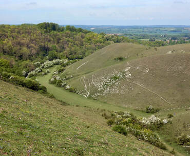
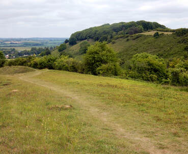
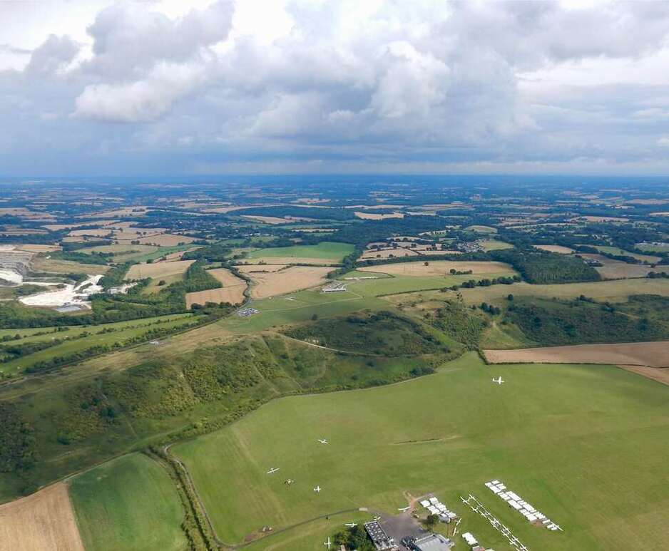
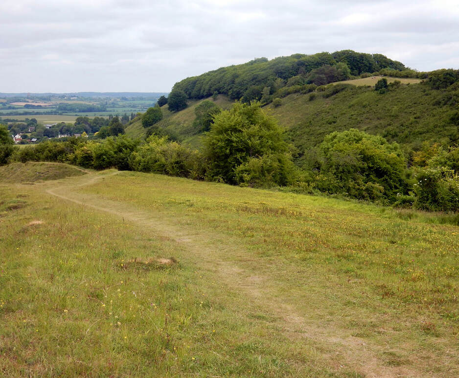
13. SMITHCOMBE, SHARPENHOE & SUNDON HILLS
Spectacular countryside! An excellent example of a Chalk escarpment and dip slope formed on the dipping Chalk beds of the Chiltern Hills. The escarpment is very sinuous, around the beechwood-topped headland of the Sharpenhoe Clappers, with many short dry valleys such as Watergutter Hole. A thin layer of boulder clay on top of the Chalk is evidence that the Anglian ice-sheet reached here. There are views over the clay vale to the Greensand Ridge. Park at the Clappers. National grid reference: TL 063 298 (the central location) Click here to see the full Bedfordshire Local Geological Site Designation Form |
|
14. STOCKGROVE COUNTRY PARK
Now part of Rushmere Country Park, you can see the underlying rust-brown Woburn Sands (Lower Greensand) in the sandy paths and blocks of ironstone, and the infertile sandy soils with their rare lowland heath vegetation. See evidence of the Ice Age in dry valleys cut by meltwater, and deposits of glacial clay, sand and gravel on top of the Woburn Sands. There is a wide variety of habitats – a lake, marshes, ancient oak woodland, conifer plantations, meadows, heaths and bogs. National grid reference: SP 917 291 Click here to see the full Bedfordshire Local Geological Site Designation Form |
|
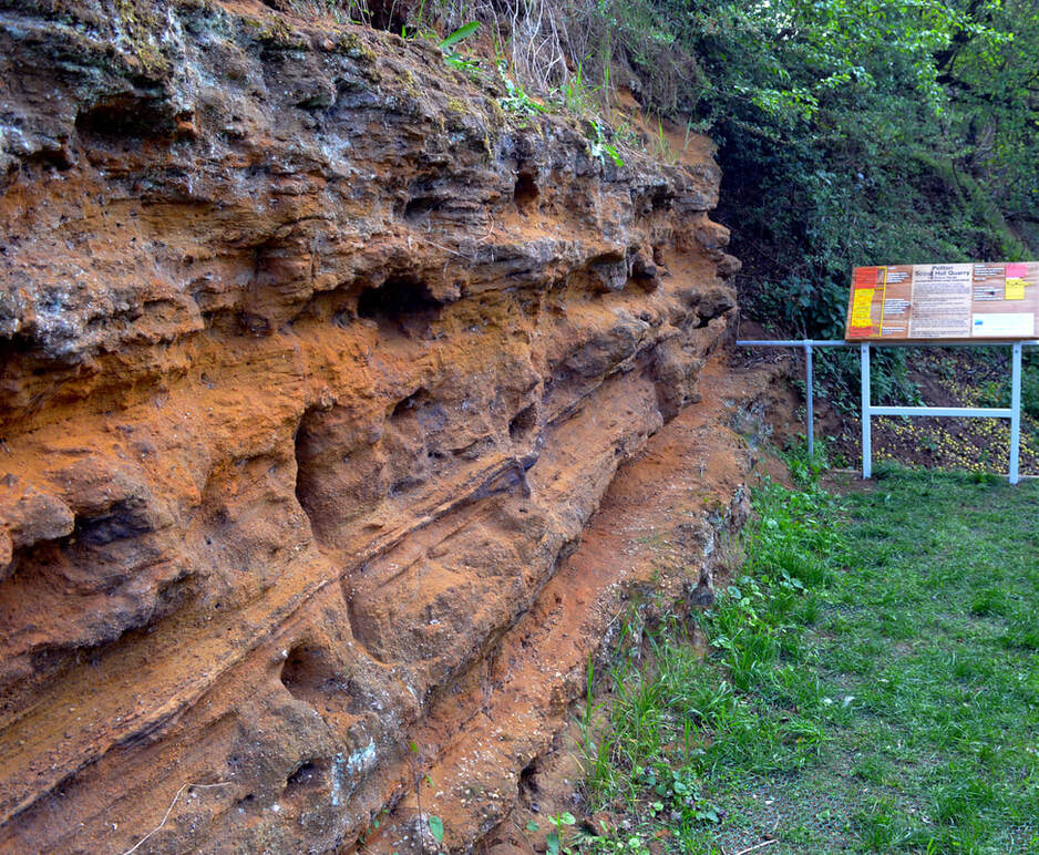
15. SCOUT HUT QUARRY, POTTON
This Woburn Sands (Lower Greensand) site can only be entered with the BGG. We arrange group visits as it's ideal for education. The low sandstone face is all that remains of a sand and gravel quarry. It was infilled during the early nineteenth century. In this small space you can see, and feel, close details of the variations in the sandstone which are described in the information boards, one for the partially-sighted and there is also a ramp for wheelchairs to get close to the face. National grid reference: TL 229 494 Click here to see the full Bedfordshire Local Geological Site Designation Form |

1. BARTON HILLS
A beautiful landscape in the Lower and Middle Chalk with a dramatic coombe in the steep face of the escarpment and a natural spring which forms a small stream, tributary dry valleys and soil creep terraces, as well as some small natural exposures of the Chalk. Take a look at the church which is built of flint and Totternhoe Stone, both from the local Chalk. National grid reference: TL 090 298 Click here for the Bedfordshire Local Geological Site Designation Form
A beautiful landscape in the Lower and Middle Chalk with a dramatic coombe in the steep face of the escarpment and a natural spring which forms a small stream, tributary dry valleys and soil creep terraces, as well as some small natural exposures of the Chalk. Take a look at the church which is built of flint and Totternhoe Stone, both from the local Chalk. National grid reference: TL 090 298 Click here for the Bedfordshire Local Geological Site Designation Form
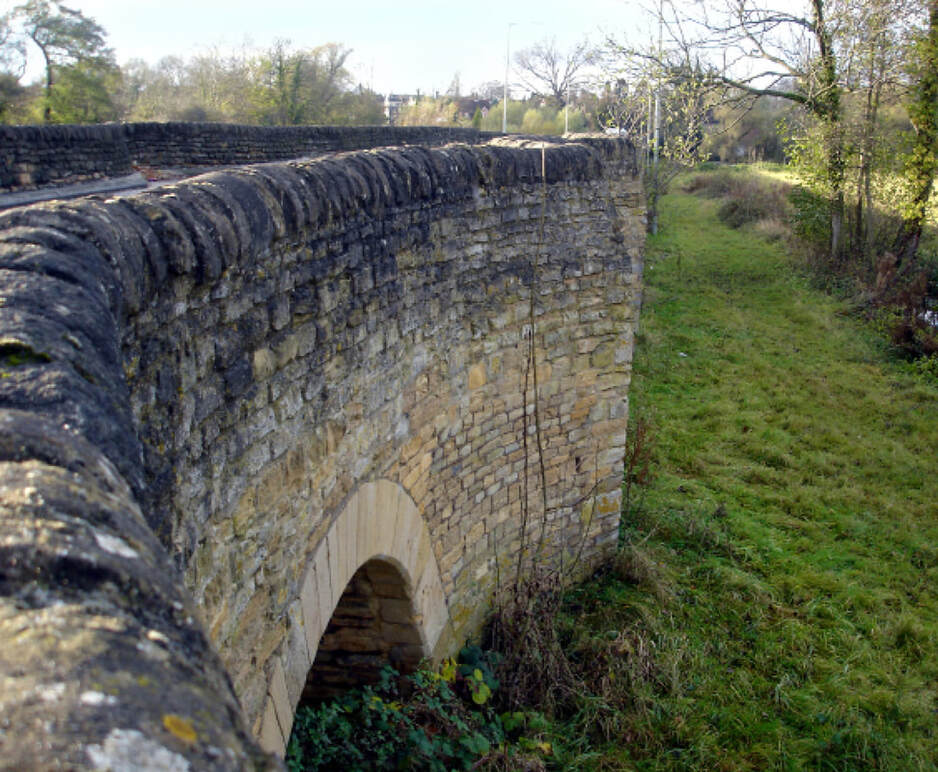
2. BROMHAM BRIDGE
This ancient bridge over the River Great Ouse near Bromham Mill is built of the local limestone which has been used to build many of older structures – churches, houses and walls – along the valley. But with no natural exposures of Middle Jurassic limestone in Bedfordshire, here you can examine this oolitic and fossil-rich rock, as well as visit the mill and follow footpaths along the river. National grid reference: TL 011 506 Click here for the Bedfordshire Local Geological Site Designation Form
This ancient bridge over the River Great Ouse near Bromham Mill is built of the local limestone which has been used to build many of older structures – churches, houses and walls – along the valley. But with no natural exposures of Middle Jurassic limestone in Bedfordshire, here you can examine this oolitic and fossil-rich rock, as well as visit the mill and follow footpaths along the river. National grid reference: TL 011 506 Click here for the Bedfordshire Local Geological Site Designation Form

3. DEEPDALE QUARRY
A former quarry in the Woburn Sands, partially landscaped, the main exposure is a long N-S cliff with excellent sedimentary features. Access is currently difficult. National grid reference: TL 212 487 Click here for the Bedfordshire Local Geological Site Designation Form
A former quarry in the Woburn Sands, partially landscaped, the main exposure is a long N-S cliff with excellent sedimentary features. Access is currently difficult. National grid reference: TL 212 487 Click here for the Bedfordshire Local Geological Site Designation Form
4. DUNSTABLE & WHIPSNADE DOWNS
A beautiful landscape on the edge of the steep escarpment of Middle Chalk with its coombes and dry valleys and dramatic views over the clay vale to the north-west. It is a SSSI for its chalk grassland with flowering plants and archaeological interest. Kensworth Nature Reserve is nearby with Chalk in situ. Tea and toilets at The Gateway Centre on top of the scarp. National grid reference: TL 005 196 Click here for the Bedfordshire Local Geological Site Designation Form
A beautiful landscape on the edge of the steep escarpment of Middle Chalk with its coombes and dry valleys and dramatic views over the clay vale to the north-west. It is a SSSI for its chalk grassland with flowering plants and archaeological interest. Kensworth Nature Reserve is nearby with Chalk in situ. Tea and toilets at The Gateway Centre on top of the scarp. National grid reference: TL 005 196 Click here for the Bedfordshire Local Geological Site Designation Form

5. KENSWORTH NATURE RESERVE
This exposure of Chalk was created during the restoration of the enormous Kensworth Chalk Pit. There are many features of the Lewes Nodular Chalk here: white Chalk, small faults and solution hollows, beautiful flint nodules and the possibility of finding fossils, plus an information board. The area around the Chalk face has been designated a Nature Reserve on account of re-created calcareous grassland. National grid reference: TL 011 199 Click here for the Bedfordshire Local Geological Site Designation Form
This exposure of Chalk was created during the restoration of the enormous Kensworth Chalk Pit. There are many features of the Lewes Nodular Chalk here: white Chalk, small faults and solution hollows, beautiful flint nodules and the possibility of finding fossils, plus an information board. The area around the Chalk face has been designated a Nature Reserve on account of re-created calcareous grassland. National grid reference: TL 011 199 Click here for the Bedfordshire Local Geological Site Designation Form

6. LANDPARK QUARRY
A crescent-shaped cliff, with deep scree at the foot, in a former quarry in the White Chalk, containing splendid flint nodules and fossils. It is within Landpark Wood, a Wildlife Trust Nature Reserve and access and the ability to manage it are difficult. National grid reference: TL 016 185 Click here for the Bedfordshire Local Geological Site Designation Form
A crescent-shaped cliff, with deep scree at the foot, in a former quarry in the White Chalk, containing splendid flint nodules and fossils. It is within Landpark Wood, a Wildlife Trust Nature Reserve and access and the ability to manage it are difficult. National grid reference: TL 016 185 Click here for the Bedfordshire Local Geological Site Designation Form
7. MUNDAY'S HILL QUARRY
This is a large working quarry in which the working has revealed a complete succession of Lower Cretaceous beds through the Woburn Sands into the Gault Clay. Access is accompanied and only by arrangement with the quarry manager. National grid reference: SP 938 280 Click here for the Bedfordshire Local Geological Site Designation Form
This is a large working quarry in which the working has revealed a complete succession of Lower Cretaceous beds through the Woburn Sands into the Gault Clay. Access is accompanied and only by arrangement with the quarry manager. National grid reference: SP 938 280 Click here for the Bedfordshire Local Geological Site Designation Form

8. OLD ST MARY’S CHURCH, CLOPHILL
This ruined church used local Woburn Sands (once called Lower Greensand) building stone. It shows many of the features of this rust-red Cretaceous sandstone. On the Greensand Ridge Walk with views over the surrounding landscape from the church tower. The reconstructed wall includes a Wall of Geology, a section across the rocks of the county with an interpretation board. Clophill Ecolodges sit next door. The site is managed by the Clophill Heritage Trust. National grid reference: TL 092 389 Click here for the Bedfordshire Local Geological Site Designation Form
This ruined church used local Woburn Sands (once called Lower Greensand) building stone. It shows many of the features of this rust-red Cretaceous sandstone. On the Greensand Ridge Walk with views over the surrounding landscape from the church tower. The reconstructed wall includes a Wall of Geology, a section across the rocks of the county with an interpretation board. Clophill Ecolodges sit next door. The site is managed by the Clophill Heritage Trust. National grid reference: TL 092 389 Click here for the Bedfordshire Local Geological Site Designation Form
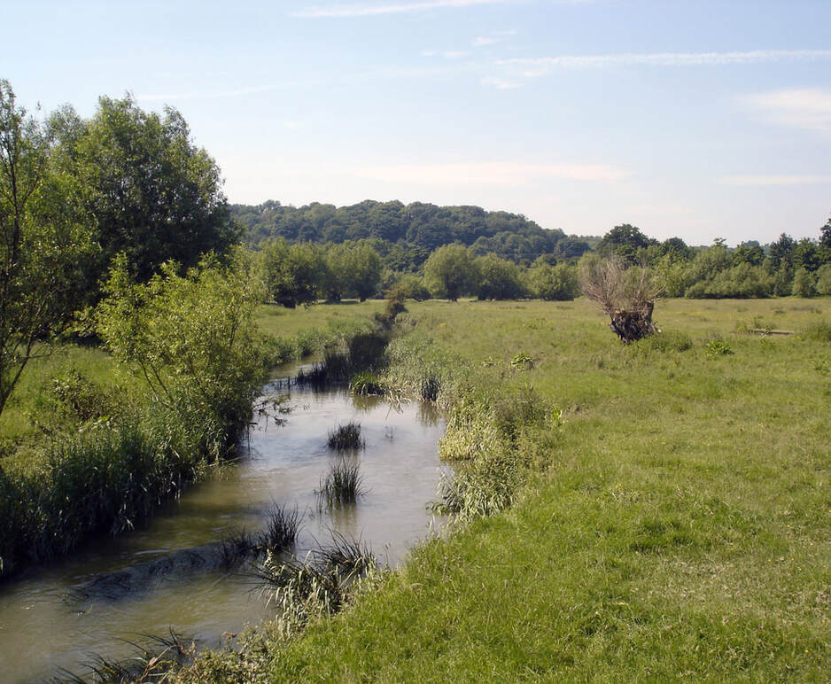
9. OUZEL VALLEY
This is a section of the River Ouzel valley where the meandering river has cut down through ice age deposits to create a series of river terraces. You may get glimpses of the underlying Woburn Sands where badgers have been digging. The site is crossed by public footpaths and is close to the start of the 40-mile Greensand Ridge Walk. National grid reference: SP 915 264 Click here for the Bedfordshire Local Geological Site Designation Form
This is a section of the River Ouzel valley where the meandering river has cut down through ice age deposits to create a series of river terraces. You may get glimpses of the underlying Woburn Sands where badgers have been digging. The site is crossed by public footpaths and is close to the start of the 40-mile Greensand Ridge Walk. National grid reference: SP 915 264 Click here for the Bedfordshire Local Geological Site Designation Form

10. RIVER IVEL, BIGGLESWADE
This is a walk along the River Ivel on the Kingfisher Way next to Biggleswade Common. You can see modern river processes on this gentle meandering river and observe the slightly higher gravel terrace of Biggleswade Common, deposited by torrential seasonal rivers during the late Ice Age. National grid reference: TL 186 463 Click here for the Bedfordshire Local Geological Site Designation Form
This is a walk along the River Ivel on the Kingfisher Way next to Biggleswade Common. You can see modern river processes on this gentle meandering river and observe the slightly higher gravel terrace of Biggleswade Common, deposited by torrential seasonal rivers during the late Ice Age. National grid reference: TL 186 463 Click here for the Bedfordshire Local Geological Site Designation Form
11. SANDY. THE PINNACLE RECREATION GROUND
This hilltop site forms a wonderful viewpoint across the broad valley to the west, where the River Ivel has cut through the Woburn Sands of the Greensand Ridge into the underlying soft Oxford Clay, with spreads of glacial and river deposits on top. The Pinnacle’s steep slopes are due to the resistant Woburn Sands which can be seen where the grass is broken through. National grid reference: TL 178 492 Click here for the Bedfordshire Local Geological Site Designation Form
This hilltop site forms a wonderful viewpoint across the broad valley to the west, where the River Ivel has cut through the Woburn Sands of the Greensand Ridge into the underlying soft Oxford Clay, with spreads of glacial and river deposits on top. The Pinnacle’s steep slopes are due to the resistant Woburn Sands which can be seen where the grass is broken through. National grid reference: TL 178 492 Click here for the Bedfordshire Local Geological Site Designation Form

12. SANDY WARREN, THE LODGE QUARRY
Building stone was taken from this quarry in the Woburn Sands (Lower Greensand) from medieval times to the 18th century including the churches at Sandy and Everton, and the packhorse bridge at Sutton. The structures in the rock here, including marked cross-bedding, have been used to build a picture of the shallow seas in which the sands were deposited. It is not safe to approach the cliff, but you can see it clearly from the fenced platform at the foot of the steps with an information board. National grid reference: TL 187 478 Click here for the Bedfordshire Local Geological Site Designation Form
Building stone was taken from this quarry in the Woburn Sands (Lower Greensand) from medieval times to the 18th century including the churches at Sandy and Everton, and the packhorse bridge at Sutton. The structures in the rock here, including marked cross-bedding, have been used to build a picture of the shallow seas in which the sands were deposited. It is not safe to approach the cliff, but you can see it clearly from the fenced platform at the foot of the steps with an information board. National grid reference: TL 187 478 Click here for the Bedfordshire Local Geological Site Designation Form
13. SMITHCOMBE, SHARPENHOE & SUNDON HILLS
Spectacular countryside! An excellent example of a Chalk escarpment and dip slope formed on the dipping Chalk beds of the Chiltern Hills. The escarpment is very sinuous, around the beechwood-topped headland of the Sharpenhoe Clappers, with many short dry valleys such as Watergutter Hole. A thin layer of boulder clay on top of the Chalk is evidence that the Anglian ice-sheet reached here. There are views over the clay vale to the Greensand Ridge. Park at the Clappers. National grid reference: TL 063 298 (the central location) Click here for the Bedfordshire Local Geological Site Designation Form
Spectacular countryside! An excellent example of a Chalk escarpment and dip slope formed on the dipping Chalk beds of the Chiltern Hills. The escarpment is very sinuous, around the beechwood-topped headland of the Sharpenhoe Clappers, with many short dry valleys such as Watergutter Hole. A thin layer of boulder clay on top of the Chalk is evidence that the Anglian ice-sheet reached here. There are views over the clay vale to the Greensand Ridge. Park at the Clappers. National grid reference: TL 063 298 (the central location) Click here for the Bedfordshire Local Geological Site Designation Form

14. STOCKGROVE COUNTRY PARK
Now part of Rushmere Country Park, you can see the underlying rust-brown Woburn Sands (Lower Greensand) in the sandy paths and blocks of ironstone, and the infertile sandy soils with their rare lowland heath vegetation. See evidence of the Ice Age in dry valleys cut by meltwater, and deposits of glacial clay, sand and gravel on top of the Woburn Sands. There is a wide variety of habitats – a lake, marshes, ancient oak woodland, conifer plantations, meadows, heaths and bogs. National grid reference: SP 917 291 Click here for the Bedfordshire Local Geological Site Designation Form
Now part of Rushmere Country Park, you can see the underlying rust-brown Woburn Sands (Lower Greensand) in the sandy paths and blocks of ironstone, and the infertile sandy soils with their rare lowland heath vegetation. See evidence of the Ice Age in dry valleys cut by meltwater, and deposits of glacial clay, sand and gravel on top of the Woburn Sands. There is a wide variety of habitats – a lake, marshes, ancient oak woodland, conifer plantations, meadows, heaths and bogs. National grid reference: SP 917 291 Click here for the Bedfordshire Local Geological Site Designation Form
15. SCOUT HUT QUARRY, POTTON
This Woburn Sands (Lower Greensand) site can only be entered with the BGG. We arrange group visits as it's ideal for education. The low sandstone face is all that remains of a sand and gravel quarry. It was infilled during the early nineteenth century. In this small space you can see, and feel, close details of the variations in the sandstone which are described in the information boards, one for the partially-sighted and there is also a ramp for wheelchairs to get close to the face. National grid reference: TL 229 494 Click here for the Bedfordshire Local Geological Site Designation Form
This Woburn Sands (Lower Greensand) site can only be entered with the BGG. We arrange group visits as it's ideal for education. The low sandstone face is all that remains of a sand and gravel quarry. It was infilled during the early nineteenth century. In this small space you can see, and feel, close details of the variations in the sandstone which are described in the information boards, one for the partially-sighted and there is also a ramp for wheelchairs to get close to the face. National grid reference: TL 229 494 Click here for the Bedfordshire Local Geological Site Designation Form
Sites of Special Scientific Interest (SSSI’s)
|
A. BIDDENHAM PIT
The remnants of an old pit in a gravel river terrace laid down towards the end of the Ice Age by the River Great Ouse. Interglacial molluscs and mammal remains have been found as well as Palaeolithic (Stone Age) tools, both of which make the site one of special scientific interest. The site has been colonised by vegetation but a small section of the gravel with fossil ice wedges can be seen, and there is an interpretation board to explain what you are seeing and its importance both geologically and archaeologically. National grid reference: TL 024 505 Click here for the SSSI Citation Form |
|
B. KENSWORTH CHALK PIT This very large chalk quarry has exposed a large extent of the Upper Cretaceous Chalk. It has the best Chalk Rock exposure in Southern England, a distinct major marker horizon allowing correlation with other areas. The Chalk Rock is very rich in fossils including rare ammonites. National grid reference: TL 015 210 |
|
C. TOTTERNHOE STONE PIT
The base of the Totternhoe Stone, a hard marker horizon in the Grey Chalk, is exposed in this large disused chalk quarry. It contains phosphate pebbles in a lime mudstone rich in shark and ray teeth. Totternhoe Stone itself is a valuable white building stone and is still extracted from a small pit in the north-west corner of the bigger site. Several large blocks can be examined. The large disused quarry is managed by the local Wildlife Trust as a calcareous grassland habitat and is next to the biological SSSI of Totternhoe Knolls. National grid reference: SP 982 222 Click here for the SSSI Citation Form |
|
A. BIDDENHAM PIT
The remnants of an old pit in a gravel river terrace laid down towards the end of the Ice Age by the River Great Ouse. Interglacial molluscs and mammal remains have been found as well as Palaeolithic (Stone Age) tools, both of which make the site one of special scientific interest. The site has been colonised by vegetation but a small section of the gravel with fossil ice wedges can be seen, and there is an interpretation board to explain what you are seeing and its importance both geologically and archaeologically. National grid reference: TL 024 505 Click here for the SSSI Citation Form |
|
B. KENSWORTH CHALK PIT
This very large chalk quarry has exposed a large extent of the Upper Cretaceous Chalk. It has the best Chalk Rock exposure in Southern England, a distinct major marker horizon allowing correlation with other areas. The Chalk Rock is very rich in fossils including rare ammonites. National grid reference: TL 015 210 |
|
C. TOTTERNHOE STONE PIT
The base of the Totternhoe Stone, a hard marker horizon in the Grey Chalk, is exposed in this large disused chalk quarry. It contains phosphate pebbles in a lime mudstone rich in shark and ray teeth. Totternhoe Stone itself is a valuable white building stone and is still extracted from a small pit in the north-west corner of the bigger site. Several large blocks can be examined. The large disused quarry is managed by the local Wildlife Trust as a calcareous grassland habitat and is next to the biological SSSI of Totternhoe Knolls. National grid reference: SP 982 222 Click here for the SSSI Citation Form |
Closed sites
These former Local Geology Sites and SSSI's are now closed and are not accessible.
BROOM QUARRY
A sequence of glaciofluvial sands and gravels with a fossiliferous organic layer and periglacial structures.
The site has now been closed and landscaped. National grid reference: TL 172 441
CAINHOE QUARRY
A quarry in the Woburn Sands with good sedimentary structures and features showing a change of environment
of deposition. Now being used for aggregate recycling, it is inaccessible. National grid reference: TL 102 375
CHAMBERLAIN’S BARN QUARRY
An exposure of Woburn Sands overlain by Gault Clay, now closed and converted to other land uses.
National grid reference: SP 928 267
CHURCHWAY’S QUARRY
A quarry in the Woburn Sands, showing a contact of the ‘Brown Sands’ with the overlying ‘Silver Sands’.
Now closed and converted to other land uses. National grid reference: SP 937 294
LEDBURN QUARRY
A small section through the Woburn Sands, not noteworthy and inaccessible. National grid reference: SP 913 236
NEW TREES QUARRY
A section through the Woburn Sands ‘Silver Sands’ and the ‘Carstone Conglomerate’ at the base of the Gault Clay.
Now closed by a change of land-use. National grid reference: SP 931 275
QUEST PIT, STEWARTBY
The last brick pit in Bedfordshire, it ceased operations in 2008, having exposed the fossil-rich Lower and Middle
Oxford Clay. Degradation of the slopes and flooding of the floor reduced its accessibility and it is now closed
and waiting for a decision on future use. National grid reference: TL 031 426
Closed sites
These former Local Geology Sites and SSSI's are now closed and are
not accessible.
BROOM QUARRY
A sequence of glaciofluvial sands and gravels with a fossiliferous organic layer and periglacial structures. The site has now been closed and landscaped.
National grid reference: TL 172 441
CAINHOE QUARRY
A quarry in the Woburn Sands with good sedimentary structures and features showing a change of environment of deposition. Now being used for aggregate recycling, it is inaccessible.
National grid reference: TL 102 375
CHAMBERLAIN’S BARN QUARRY
An exposure of Woburn Sands overlain by Gault Clay, now closed and converted to other land uses.
National grid reference: SP 928 267
CHURCHWAY’S QUARRY
A quarry in the Woburn Sands, showing a contact of the ‘Brown Sands’ with the overlying ‘Silver Sands’. Now closed and converted to other land uses.
National grid reference: SP 937 294
LEDBURN QUARRY
A small section through the Woburn Sands, not noteworthy and inaccessible.
National grid reference: SP 913 236
NEW TREES QUARRY
A section through the Woburn Sands ‘Silver Sands’ and the ‘Carstone Conglomerate’ at the base of the Gault Clay. Now closed by a change of land-use.
National grid reference: SP 931 275
QUEST PIT, STEWARTBY
The last brick pit in Bedfordshire, it ceased operations in 2008, having exposed the fossil-rich Lower and Middle Oxford Clay. Degradation of the slopes and flooding of the floor reduced its accessibility and it is now closed and waiting for a decision on future use.
National grid reference: TL 031 426
Click on the button below to download a zipped folder of de-designated site forms.